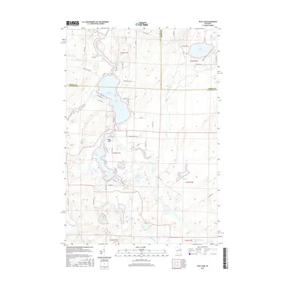
2015 Map of Post Lake
USGS Topo · Published 2015About this map
The Wolf River winds through this Northwoods landscape, anchoring a complex system of interconnected waterways at the junction of Oneida, Langlade, and Forest counties. Central to the area is the settlement of Post Lake, situated between Upper Post Lake and Lower Post Lake. The lake system is fed by numerous tributaries including Pollock Creek and Pedro Cr, while many smaller, distinct basins such as Wamin Lake, Aninnan Lake, and Miniwakan Lake dot the surrounding terrain. These water bodies, along with the Spider Cr Flowage, reflect the glacial character of this region. Local landmarks like Knoke Spring and the presence of residential clusters along Isle of Pine Dr and Wolf River Park RD indicate the area's development as a recreational and residential hub. The network of naming, from Copper Ridge LN to Loon Lake, suggests a landscape deeply valued for its wildlife and hydrology.
Find a feature on this map
109 named features on this map. Tap any name to fly to it.
Don’t see what you’re looking for? This feature index may not catch every label — zoom into the map to look around manually.
Map Details
Editions of this 2015 Post Lake Map
This is the sole edition of this map. No revisions or reprints were ever made.
Other maps of this area

1939 · Crandon
USGS Topo · 1:48,000

1940 · Monico
USGS Topo · 1:48,000

1941 · Crandon
USGS Topo · 1:48,000

1942 · Elcho
USGS Topo · 1:48,000

1942 · Pearson
USGS Topo · 1:48,000

1947 · Crandon
USGS Topo · 1:48,000

1950 · Monico
USGS Topo · 1:48,000

1950 · Elcho
USGS Topo · 1:48,000

1950 · Lily
USGS Topo · 1:48,000

1954 · Iron Mountain
USGS Topo · 1:250,000