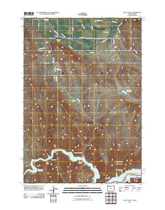
2011 Map of Posy Valley
USGS Topo · Published 2011About this map
Pine Valley and the surrounding drainage of the Snake River basin define this landscape on the Oregon-Idaho border. The town of Halfway and the nearby Baker County Fairgrounds serve as the agricultural and community anchors of the northwest corner, while the small settlement of Pine sits just north of the Pine Valley Airport. The terrain descends through several named gulches and canyons, such as Little Timber Canyon and Foster Gulch, eventually meeting the expansive waters of the Brownlee Reservoir near the southern edge of the survey.
Find a feature on this map
34 named features on this map. Tap any name to fly to it.
Don’t see what you’re looking for? This feature index may not catch every label — zoom into the map to look around manually.
Map Details
Editions of this 2011 Posy Valley Map
This is the sole edition of this map. No revisions or reprints were ever made.
Other maps of this area

1915 · Pine
USGS Topo · 1:125,000

1955 · Baker
USGS Topo · 1:250,000

1957 · Halfway
USGS Topo · 1:62,500

1957 · Copperfield
USGS Topo · 1:62,500

1957 · Sturgill Peak
USGS Topo · 1:62,500

1957 · Mineral
USGS Topo · 1:62,500

1959 · Baker
USGS Topo · 1:250,000

1980 · McCall
USGS Topo · 1:100,000

1981 · Baker
USGS Topo · 1:100,000
1987 · Mc Lain Gulch
USGS Topo · 1:24,000