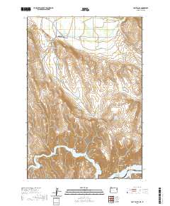
2020 Map of Posy Valley
USGS Topo · Published 2020About this map
Pine Valley and the surrounding high-desert landscape define this portion of the borderlands near the Snake River. The map documents a complex irrigation network essential for ranching and agriculture in this arid environment, featuring the McMullen Ditch and the Posy Valley Ditch, which channel water across the terrain to numerous storage sites like Laird Reservoir and Densley Reservoir. These water management features, alongside named landforms like The Saddle and Timber Canyon, illustrate the human effort to adapt to the valley's geography.
Find a feature on this map
46 named features on this map. Tap any name to fly to it.
Don’t see what you’re looking for? This feature index may not catch every label — zoom into the map to look around manually.
Map Details
Editions of this 2020 Posy Valley Map
This is the sole edition of this map. No revisions or reprints were ever made.
Other maps of this area

1915 · Pine
USGS Topo · 1:125,000

1955 · Baker
USGS Topo · 1:250,000

1957 · Halfway
USGS Topo · 1:62,500

1957 · Copperfield
USGS Topo · 1:62,500

1957 · Sturgill Peak
USGS Topo · 1:62,500

1957 · Mineral
USGS Topo · 1:62,500

1959 · Baker
USGS Topo · 1:250,000

1980 · McCall
USGS Topo · 1:100,000

1981 · Baker
USGS Topo · 1:100,000
1987 · Mc Lain Gulch
USGS Topo · 1:24,000