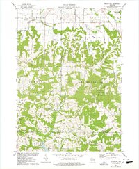
1975 Map of Potato Hill
USGS Topo · Published 1978About this map
Potato Hill rises above the transition between the agricultural plains of Lindina and the more varied topography of Summit and Seven Mile Creek. This mid-1970s landscape is defined by the headwaters of Sevenmile Creek and the intricate drainage of Cattail Valley, where scattered farmsteads are linked by a grid of family-named roads such as Petrowitz Road and Wafle Road. The map documents a rural community centered around local landmarks like St Paul Ch and numerous burial grounds, including Evergreen Cem and Barney Cem. To the south, the expansion of Lake Redstone introduces a recreation-focused geography, contrasting with the traditional farming and timbered ridges that define much of the quadrangle. For the local historian, the map preserves the exact placement of vanished rural infrastructure, from the Townhall to the Shale Pit and Gravel Pit operations that once supported local construction.
Find a feature on this map
60 named features on this map. Tap any name to fly to it.
Don’t see what you’re looking for? This feature index may not catch every label — zoom into the map to look around manually.
Map Details
Editions of this 1975 Potato Hill Map
This is the sole edition of this map. No revisions or reprints were ever made.
Other maps of this area

1901 · The Dells
USGS Topo · 1:62,500

1921 · Mauston
USGS Topo · 1:62,500

1956 · Reedsburg
USGS Topo · 1:62,500

1957 · Wisconsin Dells
USGS Topo · 1:62,500

1957 · Madison
USGS Topo · 1:250,000

1958 · La Crosse
USGS Topo · 1:250,000

1960 · Madison
USGS Topo · 1:250,000

1961 · La Crosse
USGS Topo · 1:250,000

1961 · Adams
USGS Topo · 1:62,500

1962 · Mauston
USGS Topo · 1:62,500