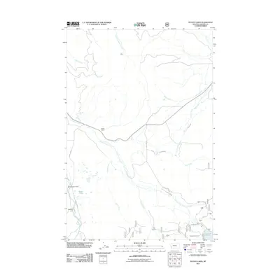
2011 Map of Potato Lakes
USGS Topo · Published 2011About this map
East Fork Rock Creek and its complex network of tributaries carve through this Granite County landscape, shaped by decades of water management and resource extraction. The presence of the Ant Mine near the headwaters of South Fork Antelope Creek highlights the mineral interests that have long driven development in these mountains. Irrigation infrastructure, including the Flint Creek Canal and the Carey Lateral, demonstrates the engineering required to support downstream agriculture, while the East Fork Reservoir serves as a primary water storage hub. Evidence of local place-naming traditions appears in landmarks such as Schoolmarm Gulch, Corral Gulch, and Dearborn Gulch. Recreational use is centered around the Potato Lakes and dedicated sites like Spillway Campground and East Fork Campground, reflecting the area's transition into a modern forest-use corridor served by Georgetown Lake Rd.
Find a feature on this map
28 named features on this map. Tap any name to fly to it.
Don’t see what you’re looking for? This feature index may not catch every label — zoom into the map to look around manually.
Map Details
Editions of this 2011 Potato Lakes Map
This is the sole edition of this map. No revisions or reprints were ever made.
Other maps of this area

1908 · Philipsburg
USGS Topo · 1:125,000

1909 · Sapphire
USGS Topo · 1:125,000

1947 · Butte
USGS Topo · 1:250,000

1958 · Butte
USGS Topo · 1:250,000

1960 · Butte
USGS Topo · 1:250,000

1962 · Butte
USGS Topo · 1:250,000

1971 · Georgetown Lake
USGS Topo · 1:24,000

1971 · Antelope Creek
USGS Topo · 1:24,000

1971 · Potato Lakes
USGS Topo · 1:24,000
1971 · Philipsburg
USGS Topo · 1:24,000