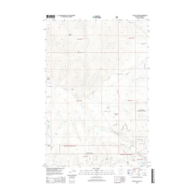
2014 Map of Potato Lakes
USGS Topo · Published 2014About this map
The John Long Mountains dominate this Granite County landscape, where the rugged topography drops into the Philipsburg Valley to the east. Water management is central to this high-country terrain, evidenced by the presence of the Flint Cr Canal, the Carey Lateral, and the E Fork Reservoir tucked into the southeastern corner. Much of the southern and eastern portion of the sheet is protected within the Deerlodge National Forest, including the namesake Potato Lakes near Dearborn Gulch. The map captures a transition from high mountain gulches like Wildcat Gulch and Eagle Canyon to the valley floor. Transportation is limited to a network of local forest routes and roads such as Skalkaho Rd, reflecting the area's use for resource management and mountain recreation.
Find a feature on this map
52 named features on this map. Tap any name to fly to it.
Don’t see what you’re looking for? This feature index may not catch every label — zoom into the map to look around manually.
Map Details
Editions of this 2014 Potato Lakes Map
This is the sole edition of this map. No revisions or reprints were ever made.
Other maps of this area

1908 · Philipsburg
USGS Topo · 1:125,000

1909 · Sapphire
USGS Topo · 1:125,000

1947 · Butte
USGS Topo · 1:250,000

1958 · Butte
USGS Topo · 1:250,000

1960 · Butte
USGS Topo · 1:250,000

1962 · Butte
USGS Topo · 1:250,000

1971 · Georgetown Lake
USGS Topo · 1:24,000

1971 · Antelope Creek
USGS Topo · 1:24,000

1971 · Potato Lakes
USGS Topo · 1:24,000
1971 · Philipsburg
USGS Topo · 1:24,000