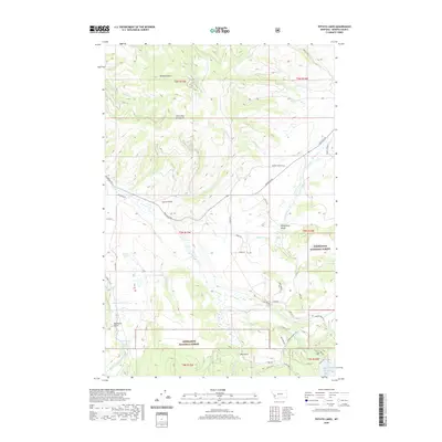
2020 Map of Potato Lakes
USGS Topo · Published 2020About this map
The John Long Mountains define the high country of Granite County in this modern study of the area north of the Deerlodge National Forest. This terrain is characterized by a dense network of drainage systems, including Wildcat Gulch, Mallard Cr, and Middle Fork Rock Creek, which flow through the forested uplands toward the lower elevations. In the eastern portion of the map, the landscape opens into the Philipsburg Valley, where human modification of the water system becomes evident through features like the Flint Cr Canal and the Carey Lateral.
Find a feature on this map
50 named features on this map. Tap any name to fly to it.
Don’t see what you’re looking for? This feature index may not catch every label — zoom into the map to look around manually.
Map Details
Editions of this 2020 Potato Lakes Map
This is the sole edition of this map. No revisions or reprints were ever made.
Other maps of this area

1908 · Philipsburg
USGS Topo · 1:125,000

1909 · Sapphire
USGS Topo · 1:125,000

1947 · Butte
USGS Topo · 1:250,000

1958 · Butte
USGS Topo · 1:250,000

1960 · Butte
USGS Topo · 1:250,000

1962 · Butte
USGS Topo · 1:250,000

1971 · Georgetown Lake
USGS Topo · 1:24,000

1971 · Antelope Creek
USGS Topo · 1:24,000

1971 · Potato Lakes
USGS Topo · 1:24,000
1971 · Philipsburg
USGS Topo · 1:24,000