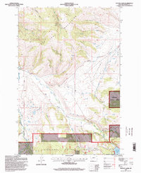
1996 Map of Potato Lakes
USGS Topo · Published 1998About this map
The John Long Mountains dominate the western half of this terrain, giving way to the Philipsburg Valley to the east. This landscape reflects a sophisticated water-management system essential for the high-altitude agriculture and ranching of the region, featuring the Flint Creek Canal, an Aqueduct, and a Siphon designed to move water across the uneven topography. In the southeast corner, the East Fork Reservoir and its spillway serve as a primary catchment point near Elk Creek.
Find a feature on this map
31 named features on this map. Tap any name to fly to it.
Don’t see what you’re looking for? This feature index may not catch every label — zoom into the map to look around manually.
Map Details
Editions of this 1996 Potato Lakes Map
This is the sole edition of this map. No revisions or reprints were ever made.
Other maps of this area

1908 · Philipsburg
USGS Topo · 1:125,000

1909 · Sapphire
USGS Topo · 1:125,000

1947 · Butte
USGS Topo · 1:250,000

1958 · Butte
USGS Topo · 1:250,000

1960 · Butte
USGS Topo · 1:250,000

1962 · Butte
USGS Topo · 1:250,000

1971 · Georgetown Lake
USGS Topo · 1:24,000

1971 · Antelope Creek
USGS Topo · 1:24,000

1971 · Potato Lakes
USGS Topo · 1:24,000
1971 · Philipsburg
USGS Topo · 1:24,000