1977 Map of Potato Peaks
USGS Topo · Published 1977About this map
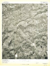
Latham and Kennady are the primary points of settlement in this orthophotoquad study produced by the Geological Survey and the Soil Conservation Service. Based on 1977 aerial imagery, the landscape is defined by the high, wooded ridges of the Ouachita Mountains, most notably Potato Peaks in the east and the long spines of Russell Mountain and Wolf Mountain. These peaks create a dramatic topography of shadow and light in the photographic record. The drainage patterns of the region are clearly visible as they wind around the northern foothills, including the meandering paths of Brazil Creek and Dog Creek. This document captures the transition between the high forest cover of the mountains and the cleared agricultural plots and rural roads surrounding the small communities, providing a literal view of the land as it was used in the late 1970s.
Find a feature on this map
7 named features on this map. Tap any name to fly to it.
Don’t see what you’re looking for? This feature index may not catch every label — zoom into the map to look around manually.
Map Details
Editions of this 1977 Potato Peaks Map
This is the sole edition of this map. No revisions or reprints were ever made.
Other maps of this area

1900 · Sallisaw
USGS Topo · 1:125,000

1900 · Winding Stair
USGS Topo · 1:125,000
1909 · Winding Stair
USGS Topo · 1:125,000

1911 · Sallisaw
USGS Topo · 1:125,000

1946 · Fort Smith
USGS Topo · 1:250,000

1950 · Mcalester
USGS Topo · 1:250,000
1959 · Heavener
USGS Topo · 1:62,500

1962 · McAlester
USGS Topo · 1:250,000

1965 · Fort Smith
USGS Topo · 1:250,000

1965 · McAlester
USGS Topo · 1:250,000