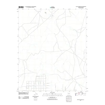
2011 Map of Potato Wash NE
USGS Topo · Published 2011About this map
Vacquero's End and the surrounding high desert of Navajo County appear here during a period of transition as rural residential developments began to overlay the older ranching landscape. The southern portion of the map is defined by a dense grid of named roads such as Dead Horse Rd, Buffington Hill Rd, and Prairie Dog Way, indicating a planned expansion into the arid terrain. This modern infrastructure contrasts with the dispersed water features vital to earlier livestock operations, including Ward Tank, Chuck Box Tank, and Duck Lake Tank. To the north, the geography is more open, characterized by Black Canyon and the Squaw Wash drainage system. The presence of Stone House reflects the sparse, localized architecture typical of the region's ranching history, while trails like Itasia Trl and Cayote Trl trace paths across the open ground.
Find a feature on this map
27 named features on this map. Tap any name to fly to it.
Don’t see what you’re looking for? This feature index may not catch every label — zoom into the map to look around manually.
Map Details
Editions of this 2011 Potato Wash NE Map
This is the sole edition of this map. No revisions or reprints were ever made.
Other maps of this area

1886 · Holbrook
USGS Topo · 1:250,000

1893 · Holbrook
USGS Topo · 1:250,000

1954 · Holbrook
USGS Topo · 1:250,000

1955 · Joseph City
USGS Topo · 1:62,500

1957 · Holbrook
USGS Topo · 1:250,000

1958 · Holbrook
USGS Topo · 1:250,000

1960 · Holbrook
USGS Topo · 1:250,000

1970 · Red Knoll
USGS Topo · 1:24,000
1970 · Relic Point
USGS Topo · 1:24,000
1970 · McCauley Sinks
USGS Topo · 1:24,000