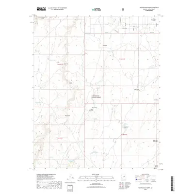
2018 Map of Potato Wash South
USGS Topo · Published 2018About this map
The Mogollon Plateau landscape dominates this high-altitude section of Navajo County, shaped by a complex system of seasonal drainage and water management. Much of the land is preserved within the Sitgreaves National Forest, where the terrain is deeply incised by Chevelon Canyon and Wildcat Canyon. The map reveals the critical importance of water in this arid environment through numerous named catchment features, including Turkey Water Catchment, Bitumul Tank, and Association Tank. These artificial improvements support ranching and wildlife in an area otherwise defined by dry beds like Potato Wash and Sandy Draw. At the northern edge, a small pocket of residential development and transit is visible near the Wisky Ranch/Chevlon Airport, where local routes like Chevlon Ave provide access to the surrounding forest and plateau lands.
Find a feature on this map
38 named features on this map. Tap any name to fly to it.
Don’t see what you’re looking for? This feature index may not catch every label — zoom into the map to look around manually.
Map Details
Editions of this 2018 Potato Wash South Map
This is the sole edition of this map. No revisions or reprints were ever made.
Other maps of this area

1886 · Holbrook
USGS Topo · 1:250,000

1893 · Holbrook
USGS Topo · 1:250,000

1954 · Holbrook
USGS Topo · 1:250,000

1957 · Holbrook
USGS Topo · 1:250,000

1958 · Holbrook
USGS Topo · 1:250,000

1960 · Holbrook
USGS Topo · 1:250,000

1961 · Woods Canyon
USGS Topo · 1:62,500

1961 · Heber
USGS Topo · 1:62,500

1965 · Chevelon Crossing
USGS Topo · 1:24,000

1970 · Red Knoll
USGS Topo · 1:24,000