1977 Map of Poteau East
USGS Topo · Published 1977About this map
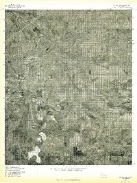
The eastern edges of Poteau and the surrounding Le Flore County landscape are documented here in late 1970s detail through rectified aerial imagery. This orthophotoquad reveals the intricate, winding course of the Poteau River as it meanders through the western half of the map, carving out oxbows and floodplains that contrast sharply with the rectangular grid of rural property lines. This hybrid format allows for a clear view of land-use patterns, showing the transition from the town's expanding footprint to the agricultural fields and wooded drainage of Nail Creek. Further east, the small community of Gilmore sits amidst a patchwork of timber and cleared acreage, illustrating the dispersed settlement style typical of the region's river valleys during this era.
Find a feature on this map
4 named features on this map. Tap any name to fly to it.
Don’t see what you’re looking for? This feature index may not catch every label — zoom into the map to look around manually.
Map Details
Editions of this 1977 Poteau East Map
This is the sole edition of this map. No revisions or reprints were ever made.
Other maps of this area

1887 · Poteau Mountain #2
USGS Topo · 1:62,500

1887 · Greenwood
USGS Topo · 1:62,500

1890 · Fort Smith
USGS Topo · 1:125,000

1890 · Poteau Mountain
USGS Topo · 1:125,000

1899 · Poteau Mountain
USGS Topo · 1:125,000

1900 · Sallisaw
USGS Topo · 1:125,000

1900 · Winding Stair
USGS Topo · 1:125,000
1909 · Winding Stair
USGS Topo · 1:125,000

1911 · Sallisaw
USGS Topo · 1:125,000

1943 · Fort Smith
USGS Topo · 1:125,000