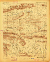
1890 Map of Poteau Mountain
USGS Topo · Published 1896About this map
High ridges of the Ouachita Mountains dominate this western Arkansas landscape during the late nineteenth century. The prominent Poteau Mountain and Sugar Loaf Mountain anchor the northern reaches of the sheet, while the Washita or Ouachita River carves through the southern terrain near Dallas. Significant to local history and genealogy is the appearance of Cherry Hill (Egger P.O.), alongside established settlements like Waldron and Cauthron.
Find a feature on this map
62 named features on this map. Tap any name to fly to it.
Don’t see what you’re looking for? This feature index may not catch every label — zoom into the map to look around manually.
Map Details
Editions of this 1890 Poteau Mountain Map
2 editions found

Other maps of this area

1879 · Poteau Mountain
USGS Topo · 1:62,500

1887 · Poteau Mountain #1
USGS Topo · 1:62,500

1887 · Mount Ida #2
USGS Topo · 1:62,500

1887 · Magazine Mountain #3
USGS Topo · 1:62,500

1887 · Magazine Mountain
USGS Topo · 1:62,500

1887 · Poteau Mountain #2
USGS Topo · 1:62,500

1887 · Greenwood
USGS Topo · 1:62,500

1890 · Magazine Mountain
USGS Topo · 1:125,000

1890 · Mount Ida
USGS Topo · 1:125,000

1890 · Fort Smith
USGS Topo · 1:125,000