
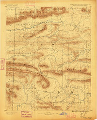
1890 Map of Poteau Mountain
USGS Topo · Published 1890About this map
Poteau Mountain dominates this late-nineteenth-century landscape along the Boundary Line between Arkansas and the Indian Territory. The settlement of Waldron serves as a focal point in the northeast, while further south, the Talihina Trail winds through the ridges of Fourche and Rich Mountain. This survey illustrates a period of frontier transition where established townships like Cauthron and Blansett are connected by rugged mountain passes such as Lookout Gap and Eagle Gap. The presence of a Toll Gate along Cedar Creek highlights early infrastructure for travelers navigating the valleys of the Fourche La Fave River. Small outposts like Cherry Hill (Egger P.O.) and Potter reveal the dispersed nature of homesteading before the expansion of the regional rail network, anchored by the river systems of the Washita or Ouachita River and Poteau River.
Find a feature on this map
67 named features on this map. Tap any name to fly to it.
Don’t see what you’re looking for? This feature index may not catch every label — zoom into the map to look around manually.
Map Details
Editions of this 1890 Poteau Mountain Map
2 editions found
Other maps of this area

1879 · Poteau Mountain
USGS Topo · 1:62,500

1887 · Poteau Mountain #1
USGS Topo · 1:62,500

1887 · Mount Ida #2
USGS Topo · 1:62,500

1887 · Magazine Mountain #3
USGS Topo · 1:62,500

1887 · Magazine Mountain
USGS Topo · 1:62,500

1887 · Poteau Mountain #2
USGS Topo · 1:62,500

1887 · Greenwood
USGS Topo · 1:62,500

1890 · Magazine Mountain
USGS Topo · 1:125,000

1890 · Mount Ida
USGS Topo · 1:125,000

1890 · Fort Smith
USGS Topo · 1:125,000