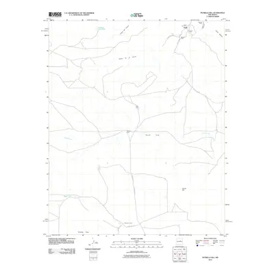
2010 Map of Potrillo Hill
USGS Topo · Published 2010About this map
Dahlia and its associated Dahlia Post Office anchor the northeastern corner of this high-plains landscape, representing a quiet hub of settlement in Guadalupe County. The area is defined by a network of established family ranching operations, including the Sanchez Ranch, Martinez Ranch, and Sisneros Ranch near the town site, with the Perez Ranch and Thompson Ranch situated further south. This distribution of named homesteads reflects a long-standing land-use pattern centered on the region's scattered water sources.
Find a feature on this map
23 named features on this map. Tap any name to fly to it.
Don’t see what you’re looking for? This feature index may not catch every label — zoom into the map to look around manually.
Map Details
Editions of this 2010 Potrillo Hill Map
This is the sole edition of this map. No revisions or reprints were ever made.
Other maps of this area

1890 · Bernal
USGS Topo · 1:125,000

1891 · Bernal
USGS Topo · 1:125,000

1894 · Bernal
USGS Topo · 1:125,000

1954 · Santa Fe
USGS Topo · 1:250,000

1954 · Fort Sumner
USGS Topo · 1:250,000

1958 · Fort Sumner
USGS Topo · 1:250,000

1958 · Santa Fe
USGS Topo · 1:250,000

1963 · Jacinto Mesa
USGS Topo · 1:24,000
1963 · Anton Chico
USGS Topo · 1:24,000
1963 · Mesa Palo Amarillo
USGS Topo · 1:24,000