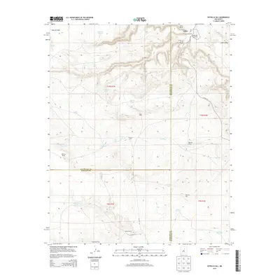
2013 Map of Potrillo Hill
USGS Topo · Published 2013About this map
Dahlia sits near the head of Cañon Blanco, marking a corner of the High Plains where ranching operations like the Sanchez Ranch and Martinez Ranch define the settlement pattern. This landscape is a complex network of drainage systems and livestock water sources, characterized by features such as Potrillo Cr and Encinosa Draw. The map documents a rugged terrain of mesas and canyons, where the local economy is etched into the earth through numerous tanks like Mesita Tank and Larranaga Tank. The intersection of San Miguel, Guadalupe, and Torrance counties occurs within these sections, highlighting the jurisdictional boundaries in this sparsely populated region. Higher elevations are marked by Potrillo Hill and the distinct contours of Cañon de Padre, providing a look at the geographic isolation and water-dependent infrastructure of northeastern New Mexico ranchlands.
Find a feature on this map
37 named features on this map. Tap any name to fly to it.
Don’t see what you’re looking for? This feature index may not catch every label — zoom into the map to look around manually.
Map Details
Editions of this 2013 Potrillo Hill Map
This is the sole edition of this map. No revisions or reprints were ever made.
Other maps of this area

1890 · Bernal
USGS Topo · 1:125,000

1891 · Bernal
USGS Topo · 1:125,000

1894 · Bernal
USGS Topo · 1:125,000

1954 · Santa Fe
USGS Topo · 1:250,000

1954 · Fort Sumner
USGS Topo · 1:250,000

1958 · Fort Sumner
USGS Topo · 1:250,000

1958 · Santa Fe
USGS Topo · 1:250,000

1963 · Jacinto Mesa
USGS Topo · 1:24,000
1963 · Anton Chico
USGS Topo · 1:24,000
1963 · Mesa Palo Amarillo
USGS Topo · 1:24,000