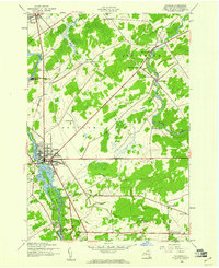
1943 Map of Potsdam
USGS Topo · Published 1961About this map
Potsdam serves as the central hub of this northern New York landscape during the early 1940s, situated where the Raquette River flows north toward the St. Lawrence. The town's grid is firmly established alongside the river, while the New York Central rail line provides critical transit through the corridor, connecting Norwood and Sisson to the southern reaches. The river's industrial and logistical importance is underscored by the presence of a Surge Tank and the complex waterways surrounding Sugar Island.
Find a feature on this map
43 named features on this map. Tap any name to fly to it.
Don’t see what you’re looking for? This feature index may not catch every label — zoom into the map to look around manually.
Map Details
Editions of this 1943 Potsdam Map
2 editions found
Other maps of this area

1905 · Waddington
USGS Topo · 1:62,500

1906 · Massena
USGS Topo · 1:62,500

1907 · Massena
USGS Topo · 1:62,500

1908 · Potsdam
USGS Topo · 1:62,500

1910 · Canton
USGS Topo · 1:62,500

1911 · Canton
USGS Topo · 1:62,500

1942 · Long Bow
USGS Topo · 1:24,000

1942 · Chase Mills
USGS Topo · 1:24,000

1942 · Norfolk
USGS Topo · 1:24,000

1943 · Potsdam
USGS Topo · 1:31,680