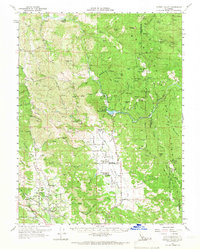
1960 Map of Potter Valley
USGS Topo · Published 1966About this map
Potter Valley Rancheria and Redwood Valley Rancheria anchor this mid-century topographic study of Mendocino County, where the hydrology of the Eel River meets the headwaters of the Russian River. The map highlights the specialized water infrastructure of the era, including the Van Arsdale Res Spillway and its associated Gaging Sta and Powerhouse. This system facilitated the diversion of water from the Eel River watershed into the Potter Valley, a significant engineering feat for regional agriculture and power generation.
Find a feature on this map
98 named features on this map. Tap any name to fly to it.
Don’t see what you’re looking for? This feature index may not catch every label — zoom into the map to look around manually.
Map Details
Editions of this 1960 Potter Valley Map
2 editions found

Other maps of this area

1920 · Ukiah
USGS Topo · 1:62,500

1922 · Willits
USGS Topo · 1:62,500

1922 · Hullville
USGS Topo · 1:62,500

1929 · Eden Valley
USGS Topo · 1:62,500

1938 · Lakeport
USGS Topo · 1:62,500

1942 · Willits
USGS Topo · 1:62,500

1943 · Pomo
USGS Topo · 1:62,500

1943 · Boonville
USGS Topo · 1:62,500

1944 · Ukiah
USGS Topo · 1:62,500

1944 · Willits
USGS Topo · 1:62,500