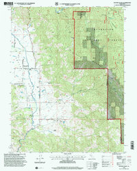
1996 Map of Potter Valley
USGS Topo · Published 2001About this map
The East Fork Russian River defines the pastoral valley floor in this mid-1990s revision, showing a landscape balanced between agricultural ranching and protected wildlands. Evidence of the area's complex history is present in the Potter Valley Rancheria and the noted Pomo (Site), marking the enduring indigenous presence in the region. The valley is organized around family holdings such as Ingle Ranch, Fritsche Ranch, and Guntley Ranch, while the northeastern portion of the map climbs sharply into the Mendocino National Forest and the peaks of Middle Mountain. Significant infrastructure, including the Powerhouse Road and an Airstrip, supports the local economy, while the Potter Valley Cem and the local High Sch serve as the community's anchors. This survey documents the intersection of the Eel River headwaters and the upper Russian River watershed.
Find a feature on this map
40 named features on this map. Tap any name to fly to it.
Don’t see what you’re looking for? This feature index may not catch every label — zoom into the map to look around manually.
Map Details
Editions of this 1996 Potter Valley Map
This is the sole edition of this map. No revisions or reprints were ever made.
Other maps of this area

1920 · Ukiah
USGS Topo · 1:62,500

1922 · Hullville
USGS Topo · 1:62,500

1938 · Lakeport
USGS Topo · 1:62,500

1943 · Pomo
USGS Topo · 1:62,500

1944 · Ukiah
USGS Topo · 1:62,500

1951 · Lake Pillsbury
USGS Topo · 1:62,500

1951 · Lakeport
USGS Topo · 1:62,500

1957 · Ukiah
USGS Topo · 1:250,000

1958 · Ukiah
USGS Topo · 1:24,000

1958 · Cow Mountain
USGS Topo · 1:24,000