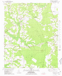
1980 Map of Potters Hill
USGS Topo · Published 1981About this map
Potters Hill sits at the intersection of local routes in a landscape defined by the winding waters of the New River and its numerous tributaries. This rural area in southeastern North Carolina is characterized by expansive swamp networks, including the Puckahoe Swamp and Back Swamp, where land rises into unique features like Big Island and Reedy Island. The map reveals a high concentration of small community centers, often anchored by rural churches and cemeteries, such as Sand Hill Ch and Baysden Chapel.
Find a feature on this map
31 named features on this map. Tap any name to fly to it.
Don’t see what you’re looking for? This feature index may not catch every label — zoom into the map to look around manually.
Map Details
Editions of this 1980 Potters Hill Map
This is the sole edition of this map. No revisions or reprints were ever made.
Other maps of this area

1943 · Kenansville
USGS Topo · 1:62,500

1948 · Kenansville
USGS Topo · 1:62,500

1948 · Richlands
USGS Topo · 1:62,500

1953 · Rocky Mount
USGS Topo · 1:250,000

1953 · Beaufort
USGS Topo · 1:250,000

1954 · Rocky Mount
USGS Topo · 1:250,000

1954 · Beaufort
USGS Topo · 1:250,000

1957 · Seven Springs
USGS Topo · 1:62,500

1958 · Deep Run
USGS Topo · 1:62,500

1965 · Richlands
USGS Topo · 1:62,500