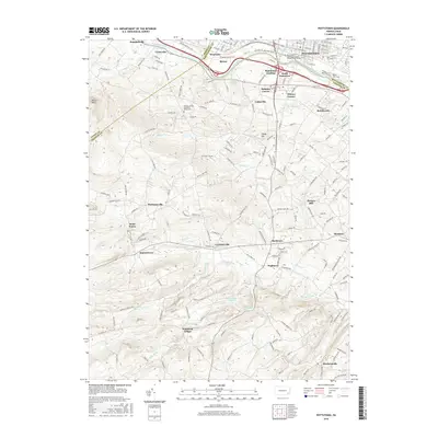
2016 Map of Pottstown
USGS Topo · Published 2016About this map
The Schuylkill River snakes along the northern edge of this territory, serving as the historical dividing line between Montgomery and Chester Counties. To the north, the industrial and educational core of Pottstown is anchored by the Montgomery County Community College-West Campus and several historical cemeteries, including Mount Zion Cem. The riverfront transitions from the developed streets of Stowe and South Pottstown to more dispersed rural hamlets as one moves south into the Chester County hills.
Find a feature on this map
169 named features on this map. Tap any name to fly to it.
Don’t see what you’re looking for? This feature index may not catch every label — zoom into the map to look around manually.
Map Details
Editions of this 2016 Pottstown Map
This is the sole edition of this map. No revisions or reprints were ever made.
Other maps of this area

1894 · Reading
USGS Topo · 1:62,500

1902 · Boyertown
USGS Topo · 1:62,500

1905 · Honey Brook
USGS Topo · 1:62,500

1906 · Phoenixville
USGS Topo · 1:62,500

1907 · Honeybrook
USGS Topo · 1:62,500

1913 · Reading
USGS Topo · 1:62,500

1915 · Reading
USGS Topo · 1:62,500

1941 · Honeybrook
USGS Topo · 1:62,500
1943 · Sassamansville
USGS Topo · 1:31,680
1943 · Boyertown
USGS Topo · 1:31,680
Featured Places
- Pottstown, PA
- West Pottsgrove, PA
- Warwick Township, PA
- East Nantmeal Township, PA
- South Pottstown, North Coventry Township