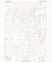
1973 Map of Potty Brown Creek
USGS Topo · Published 1976About this map
Potty Brown Creek winds through this section of the High Plains in Adams County, carving a series of drainage networks into the eastern Colorado landscape. The 1970s survey captures a rural environment defined by its watercourses and early-stage energy exploration. Significant landmarks include the Hoffman Creek and the Little Muddy Creek, which drain into broader basins south and west. This period of land use is characterized by a sparse distribution of extractive infrastructure, indicated by scattered Oil Wells, a Drill Hole, and various water Wells that suggest a reliance on subterranean resources for both ranching and industry. The map further identifies the East Fork and West Fork Seven Arrow Creek, illustrating the complex hydrological fingers that define the local topography.
Find a feature on this map
9 named features on this map. Tap any name to fly to it.
Don’t see what you’re looking for? This feature index may not catch every label — zoom into the map to look around manually.
Map Details
Editions of this 1973 Potty Brown Creek Map
This is the sole edition of this map. No revisions or reprints were ever made.
Other maps of this area

1950 · Hoyt
USGS Topo · 1:24,000

1951 · Hoyt
USGS Topo · 1:24,000

1951 · Leader SE
USGS Topo · 1:24,000

1951 · Leader
USGS Topo · 1:24,000

1953 · Denver
USGS Topo · 1:250,000

1954 · Limon
USGS Topo · 1:250,000

1954 · Sterling
USGS Topo · 1:250,000

1954 · Greeley
USGS Topo · 1:250,000

1957 · Denver
USGS Topo · 1:250,000

1957 · Limon
USGS Topo · 1:250,000