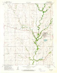
1961 Map of Potwin
USGS Topo · Published 1962About this map
Potwin stands as a focal point of industrial activity on this mid-century Kansas survey, dominated by a large Oil Refinery and its associated infrastructure. The town's layout includes a sewage disposal site and a large Settling Basin, reflecting the specialized industrial needs of the era. To the west, the smaller settlement of Brainerd sits along the Missouri Pacific railroad, which cuts a straight line across the prairie landscape.
Find a feature on this map
31 named features on this map. Tap any name to fly to it.
Don’t see what you’re looking for? This feature index may not catch every label — zoom into the map to look around manually.
Map Details
Editions of this 1961 Potwin Map
2 editions found
Other maps of this area

1888 · Eldorado
USGS Topo · 1:125,000

1889 · Newton
USGS Topo · 1:125,000

1889 · Wichita
USGS Topo · 1:125,000

1894 · Wichita
USGS Topo · 1:125,000

1894 · Newton
USGS Topo · 1:125,000

1898 · Cottonwood Falls
USGS Topo · 1:125,000

1955 · Benton
USGS Topo · 1:24,000

1955 · Greenwich
USGS Topo · 1:24,000

1955 · Wichita
USGS Topo · 1:250,000

1955 · Hutchinson
USGS Topo · 1:250,000