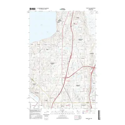
2017 Map of Poverty Bay
USGS Topo · Published 2017About this map
Federal Way and the surrounding communities of the south Puget Sound region appear in extensive detail at the turn of the 21st century. The landscape is characterized by a dense suburban network of residential streets and arterial roads like Marine View Dr S and S Dash Point Rd, which wind through the varied terrain between the shoreline of Poverty Bay and the industrial corridors of Auburn and Fife. This era shows the established suburban character of Lakeland North and Lakeland South, alongside numerous glacial lakes such as Star Lake, Steel Lake, and Mirror Lake. Significant local landmarks for genealogical research include Mountain View Cem and Gethsemane Cem, while the presence of the DeVry Univ - Washington campus reflects the area's modern development. The map captures the complex drainage patterns of Hylebos Cr and Wapato Cr as they flow toward the Commencement Bay vicinity.
Find a feature on this map
147 named features on this map. Tap any name to fly to it.
Don’t see what you’re looking for? This feature index may not catch every label — zoom into the map to look around manually.
Map Details
Editions of this 2017 Poverty Bay Map
This is the sole edition of this map. No revisions or reprints were ever made.
Other maps of this area

1897 · Tacoma
USGS Topo · 1:125,000

1900 · Tacoma
USGS Topo · 1:125,000

1941 · Tacoma South
USGS Topo · 1:62,500

1942 · Lake Tapps
USGS Topo · 1:62,500

1944 · Lake Tapps
USGS Topo · 1:62,500

1944 · Tacoma South
USGS Topo · 1:62,500

1949 · Tacoma North
USGS Topo · 1:24,000

1949 · Poverty Bay
USGS Topo · 1:24,000

1949 · Renton
USGS Topo · 1:24,000
1949 · Des Moines
USGS Topo · 1:24,000