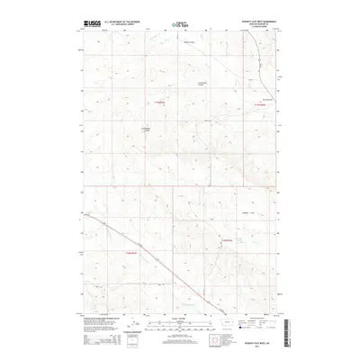
2014 Map of Poverty Flat West
USGS Topo · Published 2014About this map
Poverty Flat defines the open, high-plains landscape of eastern Dawson County in this 2014 survey. The topography is deeply incised by a network of drainage features, most notably Kelley Coulee, Cottonwood Coulee, and Cherry Coulee, which channel water toward the intermittent reaches of Deer Cr and Horse Cr. The area is characterized by this complex drainage pattern, where seasonal flows have carved out the terrain between the flatlands and the Upper Sevenmile Cr valley.
Find a feature on this map
21 named features on this map. Tap any name to fly to it.
Don’t see what you’re looking for? This feature index may not catch every label — zoom into the map to look around manually.
Map Details
Editions of this 2014 Poverty Flat West Map
This is the sole edition of this map. No revisions or reprints were ever made.
Other maps of this area

1909 · Glendive
USGS Topo · 1:250,000

1954 · Glendive
USGS Topo · 1:250,000

1957 · Glendive
USGS Topo · 1:250,000

1958 · Glendive
USGS Topo · 1:250,000
1967 · Forest Park
USGS Topo · 1:24,000

1972 · Morgan Creek School
USGS Topo · 1:24,000
1972 · Pleasant View
USGS Topo · 1:24,000

1972 · Poverty Flat West
USGS Topo · 1:24,000
1972 · Poverty Flat East
USGS Topo · 1:24,000

1972 · Stinking Coulee
USGS Topo · 1:24,000