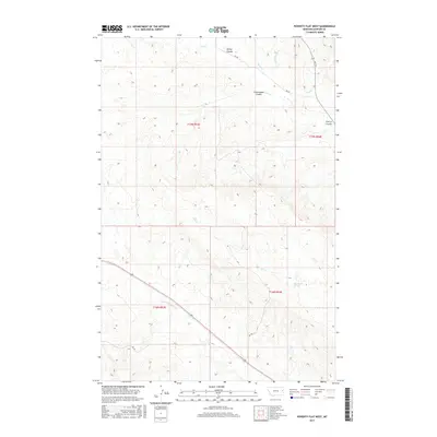
2017 Map of Poverty Flat West
USGS Topo · Published 2017About this map
Upper Sevenmile Creek and Dry Creek carve through the high plains of Dawson County, defining a landscape of deep drainage basins and prominent coulees. The terrain is marked by a series of named breaks including Kelley Coulee, Cottonwood Coulee, and Cherry Coulee, which descend toward the primary watercourses. This 2017 survey illustrates the complex topography of the Poverty Flat region, where subtle elevation changes dictate the flow of seasonal streams like Horse Creek and its tributary, East Fork Horse Creek. Isolated water sources such as Elevenmile Springs provide critical points of reference in an area otherwise characterized by vast stretches of open rangeland and sectional road networks. The map details the local infrastructure of the modern era, featuring primary access routes like RD 454 and RD 445 that thread between the coulees and creek beds.
Find a feature on this map
17 named features on this map. Tap any name to fly to it.
Don’t see what you’re looking for? This feature index may not catch every label — zoom into the map to look around manually.
Map Details
Editions of this 2017 Poverty Flat West Map
This is the sole edition of this map. No revisions or reprints were ever made.
Other maps of this area

1909 · Glendive
USGS Topo · 1:250,000

1954 · Glendive
USGS Topo · 1:250,000

1957 · Glendive
USGS Topo · 1:250,000

1958 · Glendive
USGS Topo · 1:250,000
1967 · Forest Park
USGS Topo · 1:24,000

1972 · Morgan Creek School
USGS Topo · 1:24,000
1972 · Pleasant View
USGS Topo · 1:24,000

1972 · Poverty Flat West
USGS Topo · 1:24,000
1972 · Poverty Flat East
USGS Topo · 1:24,000

1972 · Stinking Coulee
USGS Topo · 1:24,000