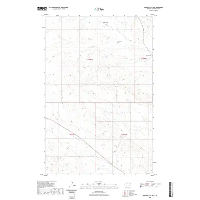
2020 Map of Poverty Flat West
USGS Topo · Published 2020About this map
Elevenmile Springs provides a rare water source in this high-plains landscape of eastern Montana, where the terrain is defined by an intricate network of drainage channels. The area is marked by a series of significant coulees, including Cottonwood Coulee, Cherry Coulee, and Kelley Coulee, which carve into the plateau between Township 17 North and Township 16 North. The drainage pattern flows primarily through Deer Cr and its tributaries, such as the S Fork Deer Cr, while the southern portion of the quadrangle is occupied by the headwaters of Upper Sevenmile Cr. This rural environment is navigated by a sparse grid of secondary routes like Fas 254, supporting a landscape dedicated to large-scale ranching and open-range land management.
Find a feature on this map
19 named features on this map. Tap any name to fly to it.
Don’t see what you’re looking for? This feature index may not catch every label — zoom into the map to look around manually.
Map Details
Editions of this 2020 Poverty Flat West Map
This is the sole edition of this map. No revisions or reprints were ever made.
Other maps of this area

1909 · Glendive
USGS Topo · 1:250,000

1954 · Glendive
USGS Topo · 1:250,000

1957 · Glendive
USGS Topo · 1:250,000

1958 · Glendive
USGS Topo · 1:250,000
1967 · Forest Park
USGS Topo · 1:24,000

1972 · Morgan Creek School
USGS Topo · 1:24,000
1972 · Pleasant View
USGS Topo · 1:24,000

1972 · Poverty Flat West
USGS Topo · 1:24,000
1972 · Poverty Flat East
USGS Topo · 1:24,000

1972 · Stinking Coulee
USGS Topo · 1:24,000