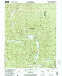
1997 Map of Powder Mill Ferry
USGS Topo · Published 2001About this map
Powder Mill Ferry serves as a focal point along the river, illustrating the historical reliance on water crossings in the Ozark highlands. This late-twentieth-century perspective, updated with 1997 imagery by the U.S. Geological Survey, shows a landscape dominated by conservation areas and natural springs. The presence of numerous family-named landmarks like Peter Mooney Mountain, Williams Mountain, and Clint Williams Spring provides a tangible link to the area's early settlers and homesteaders. Much of the terrain is managed as the Ozark National Scenic Riverways and the Rocky Creek State Conservation Area. Notable water features such as Cove Spring and Stroup Spring feed into the complex network of hollows, including Booming Shoal Hollow and Slick Rock Hollow, which define the local drainage patterns into the Current River.
Find a feature on this map
60 named features on this map. Tap any name to fly to it.
Don’t see what you’re looking for? This feature index may not catch every label — zoom into the map to look around manually.
Map Details
Editions of this 1997 Powder Mill Ferry Map
This is the sole edition of this map. No revisions or reprints were ever made.
Other maps of this area

1915 · Eminence
USGS Topo · 1:62,500

1917 · Eminence
USGS Topo · 1:62,500

1928 · Cardareva
USGS Topo · 1:62,500

1944 · Corridon
USGS Topo · 1:62,500

1945 · Round Spring
USGS Topo · 1:62,500

1947 · Sinkin
USGS Topo · 1:48,000

1947 · Corridon
USGS Topo · 1:62,500

1949 · Round Spring
USGS Topo · 1:62,500

1949 · Rolla
USGS Topo · 1:250,000

1949 · Cardareva
USGS Topo · 1:62,500