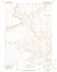
1970 Map of Powder Mountain NE
USGS Topo · Published 1973About this map
Willow Creek and its various tributaries, including the East Branch and West Branch, dominate the hydrology of this high-desert landscape in Sweetwater County. The topography is defined by sharp elevation changes along a prominent Rim, where numerous Jeep Trails wind through the breaks and drainages. Isolated landmarks such as Church Butte and Courthouse Butte stand out in the northeast, while small water sources like Lower Willow Creek Spring and the Sandy Butte Reservoir highlight the importance of water management in this arid region. The drainage patterns of Grindstone Wash and Reader Draw illustrate the erosive forces that have shaped the territory, creating a complex network of dry washes and seasonal creek beds that would have been vital orientation points for ranchers and travelers moving across this portion of Wyoming.
Find a feature on this map
14 named features on this map. Tap any name to fly to it.
Don’t see what you’re looking for? This feature index may not catch every label — zoom into the map to look around manually.
Map Details
Editions of this 1970 Powder Mountain NE Map
This is the sole edition of this map. No revisions or reprints were ever made.
Other maps of this area

1954 · Rawlins
USGS Topo · 1:250,000

1954 · Rock Springs
USGS Topo · 1:250,000

1958 · Rawlins
USGS Topo · 1:250,000

1958 · Rock Springs
USGS Topo · 1:250,000

1962 · Rawlins
USGS Topo · 1:250,000

1962 · Rock Springs
USGS Topo · 1:250,000

1967 · Rawlins
USGS Topo · 1:250,000

1970 · South Barrel Spring
USGS Topo · 1:24,000

1970 · Prehistoric Rim
USGS Topo · 1:24,000
1970 · Powder Mountain
USGS Topo · 1:24,000