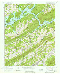
1952 Map of Powder Springs
USGS Topo · Published 1976About this map
Powder Springs sits along the Southern Railway at the base of Clinch Mountain, serving as a focal point in a landscape defined by steep ridges and the waters of Norris Lake. This 1952 field revision reveals a rural community deeply connected to its topography, where settlements and family cemeteries like the Cherry Orchard Cemetery and Hamilton Cemetery are tucked into narrow valleys like Raccoon Valley. The inclusion of the Norris Reservation and infrastructure such as the Walker Ford Lookout Tower indicates the significant role of the Tennessee Valley Authority in shaping the region’s land use and conservation. Genealogists will find a wealth of local landmarks, from the Little Barren Church to numerous schoolhouses like Wood Dale School and Navehill School, which anchored these upland Tennessee neighborhoods before mid-century modernization altered the social fabric.
Find a feature on this map
78 named features on this map. Tap any name to fly to it.
Don’t see what you’re looking for? This feature index may not catch every label — zoom into the map to look around manually.
Map Details
Editions of this 1952 Powder Springs Map
3 editions found
Other maps of this area

1897 · Maynardville
USGS Topo · 1:125,000

1900 · Maynardville
USGS Topo · 1:125,000

1935 · Luttrell
USGS Topo · 1:24,000

1935 · Straw Plains
USGS Topo · 1:48,000

1935 · Graveston
USGS Topo · 1:24,000

1935 · Joppa
USGS Topo · 1:24,000

1936 · Gorryton
USGS Topo · 1:48,000

1936 · Powder Springs
USGS Topo · 1:24,000

1936 · Ausmus
USGS Topo · 1:24,000
1936 · Clouds
USGS Topo · 1:24,000