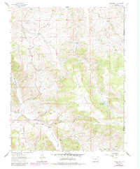
1962 Map of Powderhorn
USGS Topo · Published 1984About this map
Cebolla Creek winds through this Colorado landscape, anchoring a valley where ranching and geothermal features defined the local economy during the mid-twentieth century. The settlement of Powderhorn serves as a central hub, situated near the Cebolla Hot Springs and surrounded by established family holdings like Youmans Ranch and Howard Ranch. High terrain dominates the eastern half of the map, notably the expansive Huntsman Mesa and the specialized topography of Iron Hill and Ninemile Hill.
Find a feature on this map
41 named features on this map. Tap any name to fly to it.
Don’t see what you’re looking for? This feature index may not catch every label — zoom into the map to look around manually.
Map Details
Editions of this 1962 Powderhorn Map
3 editions found

Other maps of this area

1908 · Uncompahgre
USGS Topo · 1:125,000

1911 · Uncompahgre
USGS Topo · 1:125,000

1954 · Iris NW
USGS Topo · 1:24,000

1954 · Iola
USGS Topo · 1:24,000

1954 · Cebolla
USGS Topo · 1:24,000

1954 · Gateview
USGS Topo · 1:24,000

1956 · Montrose
USGS Topo · 1:250,000

1959 · Montrose
USGS Topo · 1:250,000

1960 · Montrose
USGS Topo · 1:250,000

1962 · Rudolph Hill
USGS Topo · 1:24,000