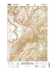
2014 Map of Powell Mountain
USGS Topo · Published 2014About this map
Powell Mountain dominates this portion of the Ochoco National Forest, marking the boundary where Crook and Grant Counties meet. This high-country landscape is defined by an intricate network of livestock-management and water-storage features, including Thompson Reservoir, Duck Puddle Reservoir, and Stump Cr Reservoir. The topography transitions from the dramatic Dahlgren Rim and Stockade Point in the west toward the high plateaus of Laughlin Table and Sunflower Flats to the east.
Find a feature on this map
65 named features on this map. Tap any name to fly to it.
Don’t see what you’re looking for? This feature index may not catch every label — zoom into the map to look around manually.
Map Details
Editions of this 2014 Powell Mountain Map
This is the sole edition of this map. No revisions or reprints were ever made.
Other maps of this area

1932 · Dayville
USGS Topo · 1:125,000

1936 · Dayville
USGS Topo · 1:125,000

1955 · Canyon City
USGS Topo · 1:250,000

1959 · Canyon City
USGS Topo · 1:250,000

1966 · Six Corners
USGS Topo · 1:24,000

1972 · Wolf Mountain
USGS Topo · 1:24,000
1972 · Aldrich Gulch
USGS Topo · 1:24,000
1981 · Powell Mtn
USGS Topo · 1:24,000

1981 · Suplee
USGS Topo · 1:24,000

1981 · Dayville
USGS Topo · 1:100,000