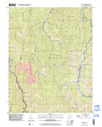
1996 Map of Powellton
USGS Topo · Published 2002About this map
Armstrong Creek and Loop Creek carve deep valleys through this part of the West Virginia coalfields during the late 1990s. The landscape is defined by the industrial extraction and transport systems of the era, from the large Strip Mine near Burnwell to the CSX rail lines and the West Virginia Turnpike winding along the western edge. Small company towns and residential clusters like Powellton, Elkridge, and Mahan sit tucked into the narrow bottomlands, reflecting the region's long-standing reliance on the narrow corridors between Armstrong Mountain and Kingston Mtn. Local genealogy is anchored by sites such as Meadow Haven Memorial Park (Cemetery) near Hamilton and the Blake Cem to the north, while features like McDunn, Kincaid, and Collinsdale illustrate the dense settlement pattern that follows the creek forks and hollows.
Find a feature on this map
57 named features on this map. Tap any name to fly to it.
Don’t see what you’re looking for? This feature index may not catch every label — zoom into the map to look around manually.
Map Details
Editions of this 1996 Powellton Map
This is the sole edition of this map. No revisions or reprints were ever made.
Other maps of this area

1891 · Raleigh
USGS Topo · 1:125,000

1897 · Kanawha Falls
USGS Topo · 1:125,000

1897 · Raleigh
USGS Topo · 1:125,000

1900 · Kanawha Falls
USGS Topo · 1:125,000

1901 · Kanawha Falls
USGS Topo · 1:125,000

1902 · Raleigh
USGS Topo · 1:125,000

1908 · Fayetteville
USGS Topo · 1:48,000

1908 · Montgomery
USGS Topo · 1:48,000

1910 · Fayetteville
USGS Topo · 1:62,500

1910 · Montgomery
USGS Topo · 1:62,500