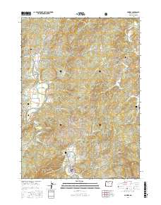
2017 Map of Powers
USGS Topo · Published 2017About this map
The South Fork Coquille River defines the lower elevations of this landscape, carving a path through the northern reaches of the Siskiyou National Forest. The settlement of Powers serves as the primary hub, situated near Powers Pond and Powers Cem. The map reveals a high density of small family and community burial sites scattered throughout the terrain, including Neal Cem, Wise Cem, and the lone Warner Grave near the South Fork Coquille River. The presence of several stretches of Railroad Grade winding past Gaylord suggests the historical importance of the timber industry and rail transport in this part of Coos County. High peaks like Hood Mtn and Barklow Mountain rise above the drainage basins of Whisky Cr and Baker Cr, while Bancroft marks a smaller node of activity in the east near Hooker Cr.
Find a feature on this map
57 named features on this map. Tap any name to fly to it.
Don’t see what you’re looking for? This feature index may not catch every label — zoom into the map to look around manually.
Map Details
Editions of this 2017 Powers Map
This is the sole edition of this map. No revisions or reprints were ever made.
Other maps of this area

1896 · Coos Bay
USGS Topo · 1:125,000

1898 · Coos Bay
USGS Topo · 1:125,000

1899 · Port Orford
USGS Topo · 1:125,000

1900 · Coos Bay
USGS Topo · 1:125,000

1903 · Port Orford
USGS Topo · 1:125,000

1928 · Sitkum
USGS Topo · 1:125,000

1942 · Coquille
USGS Topo · 1:62,500

1945 · Coquille
USGS Topo · 1:62,500

1954 · Coos Bay
USGS Topo · 1:250,000

1954 · Bone Mountain
USGS Topo · 1:62,500