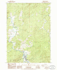
1986 Map of Powers
USGS Topo · Published 1986About this map
The South Fork Coquille River meanders through this Coos County landscape, anchoring the settlement at Powers, which serves as a central hub for the surrounding timber and river valley. In the mid-1980s, this area reflects a mix of recreation and resource management, evidenced by the presence of a Ranger Station, Powers County Park, and the Coquille Myrtle Grove State Park to the north. The terrain is marked by significant peaks such as Whobrey Mtn and Samson Mtn, with local history preserved at the Myrtle Creek Cem and Waterman Cem. The map illustrates the region's industrial and transport legacy through features like the Railroad Grade and numerous Borrow Pits, while smaller settlements like Gaylord and Bancroft dot the drainages of Myrtle Creek and Beaver Creek.
Find a feature on this map
49 named features on this map. Tap any name to fly to it.
Don’t see what you’re looking for? This feature index may not catch every label — zoom into the map to look around manually.
Map Details
Editions of this 1986 Powers Map
This is the sole edition of this map. No revisions or reprints were ever made.
Other maps of this area

1896 · Coos Bay
USGS Topo · 1:125,000

1898 · Coos Bay
USGS Topo · 1:125,000

1899 · Port Orford
USGS Topo · 1:125,000

1900 · Coos Bay
USGS Topo · 1:125,000

1903 · Port Orford
USGS Topo · 1:125,000

1928 · Sitkum
USGS Topo · 1:125,000

1942 · Coquille
USGS Topo · 1:62,500

1945 · Coquille
USGS Topo · 1:62,500

1954 · Coos Bay
USGS Topo · 1:250,000

1954 · Bone Mountain
USGS Topo · 1:62,500