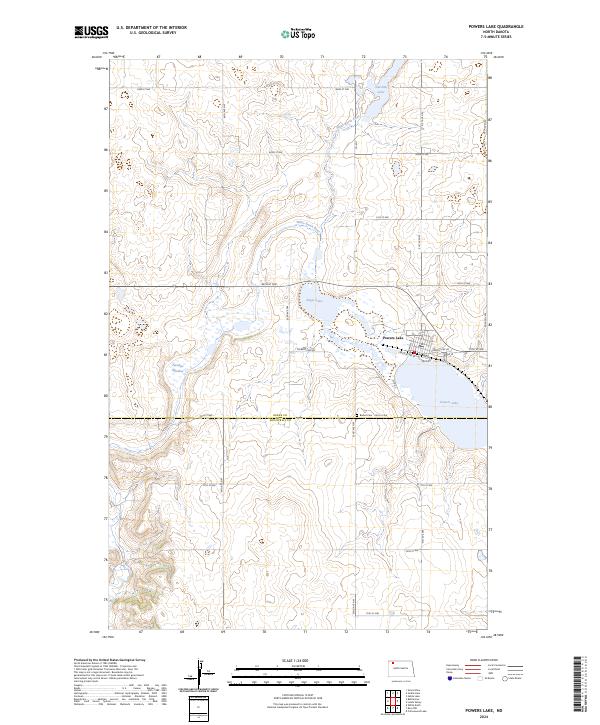
2024 Map of Powers Lake
USGS Topo · Published 2024About this map
The town of Powers Lake serves as a focal point for this section of the prairie, situated along the eastern edge of the large water body from which it takes its name. The landscape is defined by the White Earth River winding southward from Smishek Lake toward the county line, cutting through a topography rich with wetlands and potholes. Conservation efforts are evident across the central portion of the map, where the sprawling Burke County Waterfowl Production Area preserves vital habitat around Enget Lake and several unnamed basins. This area straddles the boundary of Burke and Mountrail counties, reflecting the region's agricultural and natural resource management. Local genealogy is anchored by the presence of Bethel Cem located just south of the town, while the grid of section roads like Powers Lake Rd and 80th St NW provide access to the surrounding farmsteads and the depression known as Paradise Meadow.
Find a feature on this map
23 named features on this map. Tap any name to fly to it.
Don’t see what you’re looking for? This feature index may not catch every label — zoom into the map to look around manually.
Map Details
Editions of this 2024 Powers Lake Map
This is the sole edition of this map. No revisions or reprints were ever made.
Other maps of this area

1953 · Williston
USGS Topo · 1:250,000

1957 · Williston
USGS Topo · 1:250,000

1969 · Ross NW
USGS Topo · 1:24,000

1969 · White Earth
USGS Topo · 1:24,000
1974 · Helde Lake
USGS Topo · 1:24,000

1974 · Grubb Lake
USGS Topo · 1:24,000

1974 · Grand View
USGS Topo · 1:24,000

1977 · Powers Lake
USGS Topo · 1:24,000

1978 · Battleview
USGS Topo · 1:24,000
1978 · Lunds Valley
USGS Topo · 1:24,000