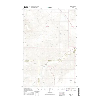
2014 Map of Pownal
USGS Topo · Published 2014About this map
Arrow Cr winds through this central Montana landscape, marking a topographic boundary between the elevated plateau of Arrow Creek Bench and the lower drainage basins. The settlement of Pownal and the nearby Ole Coulee are situated near the intersection of several county lines, where Chouteau, Fergus, and Judith Basin counties meet. The terrain is defined by dramatic geological features, most notably the prominent Square Butte in the northwest and the eroded formations known as The Badlands to the south.
Find a feature on this map
23 named features on this map. Tap any name to fly to it.
Don’t see what you’re looking for? This feature index may not catch every label — zoom into the map to look around manually.
Map Details
Editions of this 2014 Pownal Map
This is the sole edition of this map. No revisions or reprints were ever made.
Other maps of this area

1890 · Fort Benton
USGS Topo · 1:250,000

1892 · Fort Benton
USGS Topo · 1:250,000

1897 · Fort Benton
USGS Topo · 1:250,000

1954 · Great Falls
USGS Topo · 1:250,000

1957 · Great Falls
USGS Topo · 1:250,000

1972 · Square Butte SE
USGS Topo · 1:24,000

1972 · Square Butte
USGS Topo · 1:24,000
1978 · Strouf Island
USGS Topo · 1:24,000

1978 · Leiberg Coulee
USGS Topo · 1:24,000
1978 · Geraldine
USGS Topo · 1:24,000