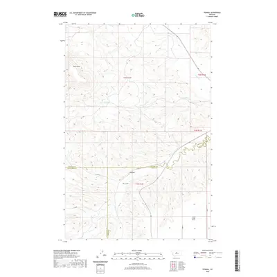
2020 Map of Pownal
USGS Topo · Published 2020About this map
Pownal stands at the intersection of Chouteau, Fergus, and Judith Basin counties, serving as a focal point for this expansive section of central Montana. The landscape is defined by the high, flat-topped profile of Square Butte in the northwest and the broad expanse of the Arrow Creek Bench to the southeast. Waterways such as Arrow Creek, Cottonwood Creek, and Surprise Creek carve intricate drainages through the terrain, creating a network of coulees including Ole Coulee. The surveying lines of the Public Land Survey System divide the territory into sections within Township 20 North and Township 19 North, while arterial routes like Pownal Road and County Road 201 link the isolated homesteads and ranchlands. This detailed record illustrates the persistent rural character of the region, where the geography of the creek beds and coulees dictates the placement of local infrastructure and land use.
Find a feature on this map
21 named features on this map. Tap any name to fly to it.
Don’t see what you’re looking for? This feature index may not catch every label — zoom into the map to look around manually.
Map Details
Editions of this 2020 Pownal Map
This is the sole edition of this map. No revisions or reprints were ever made.
Other maps of this area

1890 · Fort Benton
USGS Topo · 1:250,000

1892 · Fort Benton
USGS Topo · 1:250,000

1897 · Fort Benton
USGS Topo · 1:250,000

1954 · Great Falls
USGS Topo · 1:250,000

1957 · Great Falls
USGS Topo · 1:250,000

1972 · Square Butte SE
USGS Topo · 1:24,000

1972 · Square Butte
USGS Topo · 1:24,000
1978 · Strouf Island
USGS Topo · 1:24,000

1978 · Leiberg Coulee
USGS Topo · 1:24,000
1978 · Geraldine
USGS Topo · 1:24,000