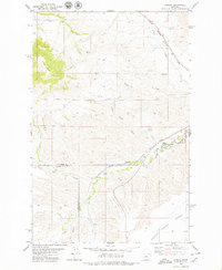
1979 Map of Pownal
USGS Topo · Published 1979About this map
Pownal and the surrounding high plains of Central Montana are defined here by a complex topography of sharp-edged buttes and deep creek incisions. The rail corridor of the Chicago Milwaukee St Paul and Pacific cuts diagonally across the landscape, following the lower elevations near Cowboy Creek and Arrow Creek as it navigates the tri-county junction of Chouteau, Judith Basin, and Fergus counties. This 1970s survey illustrates a region where water is a precious resource, marked by scattered Springs and a Flowing Well essential for ranching and agriculture on the Bench. Significant geographic features like Square Butte and the erosion-carved terrain of The Badlands near Surprise Cr dominate the western and southern sections, providing a clear look at the geological transitions of the Judith Basin area.
Find a feature on this map
21 named features on this map. Tap any name to fly to it.
Don’t see what you’re looking for? This feature index may not catch every label — zoom into the map to look around manually.
Map Details
Editions of this 1979 Pownal Map
This is the sole edition of this map. No revisions or reprints were ever made.
Other maps of this area

1890 · Fort Benton
USGS Topo · 1:250,000

1892 · Fort Benton
USGS Topo · 1:250,000

1897 · Fort Benton
USGS Topo · 1:250,000

1954 · Great Falls
USGS Topo · 1:250,000

1957 · Great Falls
USGS Topo · 1:250,000

1972 · Square Butte SE
USGS Topo · 1:24,000

1972 · Square Butte
USGS Topo · 1:24,000
1978 · Strouf Island
USGS Topo · 1:24,000

1978 · Leiberg Coulee
USGS Topo · 1:24,000
1978 · Geraldine
USGS Topo · 1:24,000