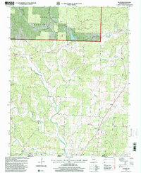
1997 Map of Poynor
USGS Topo · Published 2000About this map
Poynor and Ponder serve as the primary hubs in this rural landscape of southern Missouri, surveyed in the late 1990s as it transitions toward the Arkansas border. The terrain is defined by the extensive drainage systems of the North Fork and East Fork of Fourche Creek, which converge amidst the wooded elevations of the Mark Twain National Forest. The map is particularly dense with small family and community burial grounds, including the Old Ponder Cemetery, Plank Cemetery, and Murrell Cemetery, reflecting generations of local settlement near the Ripley County Fairground.
Find a feature on this map
43 named features on this map. Tap any name to fly to it.
Don’t see what you’re looking for? This feature index may not catch every label — zoom into the map to look around manually.
Map Details
Editions of this 1997 Poynor Map
This is the sole edition of this map. No revisions or reprints were ever made.
Other maps of this area

1935 · Reyno
USGS Topo · 1:62,500

1939 · Doniphan
USGS Topo · 1:62,500

1941 · Gatewood
USGS Topo · 1:62,500

1945 · Doniphan
USGS Topo · 1:62,500

1945 · Gatewood
USGS Topo · 1:62,500

1957 · Poplar Bluff
USGS Topo · 1:250,000

1959 · Poplar Bluff
USGS Topo · 1:250,000

1960 · Poplar Bluff
USGS Topo · 1:250,000

1965 · Gatewood
USGS Topo · 1:24,000
1965 · Bardley
USGS Topo · 1:24,000