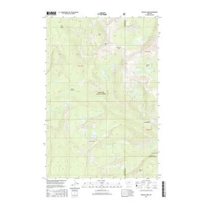
2017 Map of Pozega Lakes
USGS Topo · Published 2017About this map
Danielsville and Indian Meadows anchor the eastern and central reaches of this high-altitude landscape within the Deerlodge National Forest. This section of the Flint Creek Range is defined by a dense concentration of alpine waters, including the namesake Pozega Lakes and the tiered Upper, Middle, and Lower Bowman Lake system. The terrain is marked by dramatic elevation changes, rising to prominent points like Racetrack Peak and falling into deep glacial depressions such as Dempsey Basin and Finley Basin. A complex network of drainages, including Racetrack Cr, Boulder Cr, and Dempsey Cr, carves through the forest, illustrating the rugged hydrological patterns that dominate the borders of Granite, Powell, and Deer Lodge Counties. The presence of Thornton Ridge and Racetrack Pass indicates the historic routes used to navigate these steep divides between the mountain basins.
Find a feature on this map
65 named features on this map. Tap any name to fly to it.
Don’t see what you’re looking for? This feature index may not catch every label — zoom into the map to look around manually.
Map Details
Editions of this 2017 Pozega Lakes Map
This is the sole edition of this map. No revisions or reprints were ever made.
Other maps of this area

1889 · Helena
USGS Topo · 1:250,000

1893 · Helena
USGS Topo · 1:250,000

1899 · Helena
USGS Topo · 1:250,000

1903 · Helena
USGS Topo · 1:250,000

1908 · Philipsburg
USGS Topo · 1:125,000

1947 · Butte
USGS Topo · 1:250,000

1958 · Butte
USGS Topo · 1:250,000

1960 · Butte
USGS Topo · 1:250,000

1961 · Anaconda
USGS Topo · 1:62,500

1962 · Butte
USGS Topo · 1:250,000