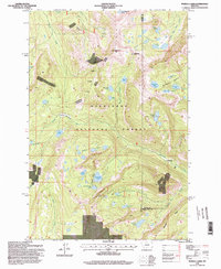
1996 Map of Pozega Lakes
USGS Topo · Published 1998About this map
The high ridges of the Deerlodge National Forest dominate this mountain landscape at the boundary of Granite and Powell counties. The area is defined by its deep history of resource extraction, with multiple industrial footprints scattered across the terrain, including the Powell Mines, the Tungsten Mine, and numerous unnamed Mines and Prospects. A central human-interest landmark is Danielsville (Site), a former settlement along Racetrack creek that speaks to the era of early mountain mining camps.
Find a feature on this map
45 named features on this map. Tap any name to fly to it.
Don’t see what you’re looking for? This feature index may not catch every label — zoom into the map to look around manually.
Map Details
Editions of this 1996 Pozega Lakes Map
This is the sole edition of this map. No revisions or reprints were ever made.
Other maps of this area

1889 · Helena
USGS Topo · 1:250,000

1893 · Helena
USGS Topo · 1:250,000

1899 · Helena
USGS Topo · 1:250,000

1903 · Helena
USGS Topo · 1:250,000

1908 · Philipsburg
USGS Topo · 1:125,000

1947 · Butte
USGS Topo · 1:250,000

1958 · Butte
USGS Topo · 1:250,000

1960 · Butte
USGS Topo · 1:250,000

1961 · Anaconda
USGS Topo · 1:62,500

1962 · Butte
USGS Topo · 1:250,000