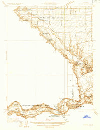
1933 Map of Prado
USGS Topo · Published 1933About this map
The agricultural and hydrological landscape of Santa Ana Del Chino is defined by an intricate network of irrigation and water management features. During the early 1930s, the Santa Ana River wound through the Canyon de Santa Ana, supporting a series of critical waterways including the Anaheim Canal, Santa Ana Valley Canal, and the Imperial Canal. This 1933 survey details a period before major flood control projects permanently altered the valley floor, showing the rail-dependent settlements of Prado, Greda, and Scully along the Atchison Topeka and Santa Fe RR. Institutional and social landmarks such as the California Junior Republic School and Los Serranos Country Club appear alongside family operations like Pellissier Ranch, illustrating the transition from large rancho holdings to organized civic and agricultural development.
Find a feature on this map
48 named features on this map. Tap any name to fly to it.
Don’t see what you’re looking for? This feature index may not catch every label — zoom into the map to look around manually.
Map Details
Editions of this 1933 Prado Map
This is the sole edition of this map. No revisions or reprints were ever made.
Other maps of this area

1894 · Pomona
USGS Topo · 1:62,500

1896 · Anaheim
USGS Topo · 1:62,500

1897 · Pomona
USGS Topo · 1:62,500

1897 · Cucamonga
USGS Topo · 1:62,500

1898 · Pomona
USGS Topo · 1:62,500

1898 · Anaheim
USGS Topo · 1:62,500

1900 · Cucamonga
USGS Topo · 1:62,500

1901 · Southern California Sheet No. 1
USGS Topo · 1:250,000

1901 · Anaheim
USGS Topo · 1:62,500

1902 · Corona
USGS Topo · 1:125,000