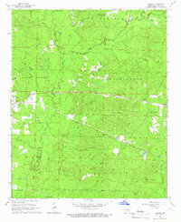
1964 Map of Prague
USGS Topo · Published 1966About this map
Hurricane Creek and its many tributaries, including Simpson Creek and Mill Creek, define the drainage patterns of this Grant County landscape in the mid-1960s. The small settlement of Prague sits at the intersection of local routes, while the community of Center Grove serves as a northern focal point. This era shows a rural landscape punctuated by several country burial grounds and houses of worship, such as Providence Ch and the Church of Jesus-Christ. Genealogical researchers can locate specific family-related sites including the Hardin Cem, Oak Grove Cem, and Center Campground Cem. The presence of several Gravel Pits and a Gaging Station on the creek indicates the local importance of natural resource extraction and water management during this period of Arkansas's history.
Find a feature on this map
29 named features on this map. Tap any name to fly to it.
Don’t see what you’re looking for? This feature index may not catch every label — zoom into the map to look around manually.
Map Details
Editions of this 1964 Prague Map
3 editions found
Other maps of this area

1932 · Pastoria
USGS Topo · 1:62,500

1935 · Pastoria
USGS Topo · 1:62,500

1955 · Little Rock
USGS Topo · 1:250,000

1956 · Little Rock
USGS Topo · 1:250,000

1960 · Little Rock
USGS Topo · 1:250,000

1962 · Pine Bluff NW
USGS Topo · 1:24,000

1964 · Little Rock
USGS Topo · 1:250,000

1964 · Sheridan
USGS Topo · 1:24,000

1964 · Cane Creek
USGS Topo · 1:24,000

1964 · Belfast
USGS Topo · 1:24,000