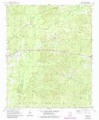
1964 Map of Prague
USGS Topo · Published 1984About this map
Hurricane Creek and its many tributaries, including White Oak Creek and Simpson Creek, carve through this section of Grant County. The landscape is a network of rural watercourses and small settlements, centered around the community of Prague and the nearby Sheridan Municipal Airport. This mid-century survey reveals a territory deeply rooted in local history, marked by numerous family and community burial grounds such as Hardin Cem, Oak Grove Cem, and Genter Campground Cem. Religious life is anchored by Providence Ch and the Church of Jesus Christ. Evidence of local industry and infrastructure is visible through several Gravel Pit operations and a Gaging Station located along the creek, while Tollman Br serves as a named landmark for early travelers crossing the local wetlands.
Find a feature on this map
29 named features on this map. Tap any name to fly to it.
Don’t see what you’re looking for? This feature index may not catch every label — zoom into the map to look around manually.
Map Details
Editions of this 1964 Prague Map
3 editions found
Other maps of this area

1932 · Pastoria
USGS Topo · 1:62,500

1935 · Pastoria
USGS Topo · 1:62,500

1955 · Little Rock
USGS Topo · 1:250,000

1956 · Little Rock
USGS Topo · 1:250,000

1960 · Little Rock
USGS Topo · 1:250,000

1962 · Pine Bluff NW
USGS Topo · 1:24,000

1964 · Little Rock
USGS Topo · 1:250,000

1964 · Sheridan
USGS Topo · 1:24,000

1964 · Cane Creek
USGS Topo · 1:24,000

1964 · Belfast
USGS Topo · 1:24,000