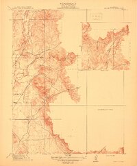
1912 Map of Prairie Creek
USGS Topo · Published 1912About this map
Honcut and its surrounding countryside are defined by a complex network of waterways that once shaped the border between Butte and Yuba counties in the early 1900s. The landscape is dominated by the confluence of North Honcut Creek, South Honcut Creek, and Prairie Creek, creating a riparian corridor that dictated the placement of early transportation routes. Local education and community life were centered at the Salem School in the north and the Buckeye School further south, providing essential landmarks for genealogists tracing pioneer families. The presence of established thoroughfares like the Marysville and Laporte Road and Bangor Road highlights the area's role as a transit point between regional hubs. This survey, conducted during the administration of Governor J. N. Gillett, illustrates the intricate topography of the low hills and creek bottoms before modern development altered the rural character of the Sacramento Valley foothills.
Find a feature on this map
12 named features on this map. Tap any name to fly to it.
Don’t see what you’re looking for? This feature index may not catch every label — zoom into the map to look around manually.
Map Details
Editions of this 1912 Prairie Creek Map
3 editions found
Other maps of this area

1888 · Marysville
USGS Topo · 1:125,000

1888 · Smartsville
USGS Topo · 1:125,000

1891 · Marysville
USGS Topo · 1:125,000

1891 · Smartsville
USGS Topo · 1:125,000

1892 · Smartsville
USGS Topo · 1:125,000

1894 · Smartsville
USGS Topo · 1:125,000

1894 · Marysville
USGS Topo · 1:125,000

1895 · Marysville
USGS Topo · 1:125,000

1895 · Smartsville
USGS Topo · 1:125,000

1911 · Browns Valley
USGS Topo · 1:31,680