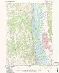
1983 Map of Prairie Du Chien
USGS Topo · Published 1983About this map
The Mississippi River valley serves as a dramatic borderland between Iowa and Wisconsin, dominated by the urban center of Prairie Du Chien on the eastern bank. This riverine landscape is defined by a complex network of channels and islands, including the Upper Mississippi River Wild Life and Fish Refuge and islands such as Scrogum Island and Roseau Island. The map shows the convergence of the Wisconsin River from the southeast and the Yellow River from the west, creating a significant waterway junction.
Find a feature on this map
63 named features on this map. Tap any name to fly to it.
Don’t see what you’re looking for? This feature index may not catch every label — zoom into the map to look around manually.
Map Details
Editions of this 1983 Prairie Du Chien Map
2 editions found
Other maps of this area

1902 · Elkader
USGS Topo · 1:125,000

1903 · Waukon
USGS Topo · 1:125,000

1929 · Prairie Du Chien
USGS Topo · 1:62,500

1932 · Prairie Du Chien
USGS Topo · 1:62,500

1958 · La Crosse
USGS Topo · 1:250,000

1959 · Dubuque
USGS Topo · 1:250,000

1961 · Dubuque
USGS Topo · 1:250,000

1961 · La Crosse
USGS Topo · 1:250,000

1962 · Dubuque
USGS Topo · 1:250,000

1962 · Clayton
USGS Topo · 1:24,000