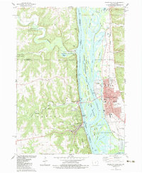
1983 Map of Prairie Du Chien
USGS Topo · Published 1983About this map
Prairie Du Chien and its surrounding riverine landscape are defined by the convergence of major waterways and ancient cultural sites. The map illustrates the complex braiding of the Mississippi River channel near its junction with the Wisconsin River, featuring a dense network of islands including Scrogum Island and Hunter Island. This 1980s-era documentation highlights the preservation of early indigenous earthworks at Effigy Mounds National Monument, while the eastern bank shows the established urban grid of Prairie Du Chien with its institutional landmarks like St Marys Academy and the Nat Cem. On the Iowa side, the riverside towns of McGregor and Marquette are tucked beneath the bluffs of Pikes Peak State Park, while the Burlington Northern and Chicago Milwaukee ST Paul And Pacific rail lines trace the narrow corridors between the hills and the water.
Find a feature on this map
68 named features on this map. Tap any name to fly to it.
Don’t see what you’re looking for? This feature index may not catch every label — zoom into the map to look around manually.
Map Details
Editions of this 1983 Prairie Du Chien Map
2 editions found
Other maps of this area

1902 · Elkader
USGS Topo · 1:125,000

1903 · Waukon
USGS Topo · 1:125,000

1929 · Prairie Du Chien
USGS Topo · 1:62,500

1932 · Prairie Du Chien
USGS Topo · 1:62,500

1958 · La Crosse
USGS Topo · 1:250,000

1959 · Dubuque
USGS Topo · 1:250,000

1961 · Dubuque
USGS Topo · 1:250,000

1961 · La Crosse
USGS Topo · 1:250,000

1962 · Dubuque
USGS Topo · 1:250,000

1962 · Clayton
USGS Topo · 1:24,000