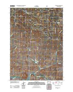
2011 Map of Prairie Hill
USGS Topo · Published 2011About this map
Prairie Hill stands as a prominent elevation in this high-desert landscape of Crook County, where water management defines the remote terrain. The southern portion of the area is dominated by the winding course of the Crooked River, while a network of seasonal and perennial drainages such as Spring Creek and Meadow Branch feed into several essential catchment points. Features like Dick Reservoir, maintained by Dick Dam, and the nearby Township Reservoir illustrate the critical nature of water storage for ranching operations. The local infrastructure is oriented around livestock and land management, centered on the Dick Ranch and the open expanse of Horse Prairie. Access to these points is provided by a web of rural routes, including Little Horse Heaven Rd and Sand Spring Rd, which connect the isolated homesteads and grazing lands to the larger region.
Find a feature on this map
19 named features on this map. Tap any name to fly to it.
Don’t see what you’re looking for? This feature index may not catch every label — zoom into the map to look around manually.
Map Details
Editions of this 2011 Prairie Hill Map
This is the sole edition of this map. No revisions or reprints were ever made.
Other maps of this area

1951 · Post
USGS Topo · 1:62,500

1951 · Lookout Mtn
USGS Topo · 1:62,500

1955 · Bend
USGS Topo · 1:250,000

1957 · Bend
USGS Topo · 1:250,000

1958 · Bend
USGS Topo · 1:250,000

1965 · Williams Prairie
USGS Topo · 1:24,000

1981 · Prineville
USGS Topo · 1:100,000

1982 · Arrowwood Point
USGS Topo · 1:24,000
1983 · Committee Creek
USGS Topo · 1:24,000
1990 · Lookout Mountain
USGS Topo · 1:24,000