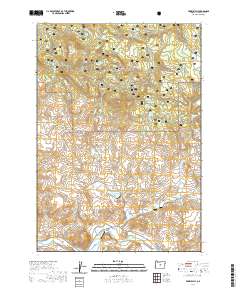
2020 Map of Prairie Hill
USGS Topo · Published 2020About this map
Ochoco National Forest defines the northern half of this landscape, where the elevation rises toward Prairie Hill and the distinctive Black Chunk Canyon. This 2020 survey documents a transition from the wooded uplands to the river valley in the south, where the Crooked River cuts across the corner of the sheet. The terrain is marked by a complex network of seasonal drainage and perennial sources, including Little Horse Heaven Cr, Meadow Br, and numerous vital watering points like Goldie Spring, Coyote Spring, and Brummer Springs.
Find a feature on this map
36 named features on this map. Tap any name to fly to it.
Don’t see what you’re looking for? This feature index may not catch every label — zoom into the map to look around manually.
Map Details
Editions of this 2020 Prairie Hill Map
This is the sole edition of this map. No revisions or reprints were ever made.
Other maps of this area

1951 · Post
USGS Topo · 1:62,500

1951 · Lookout Mtn
USGS Topo · 1:62,500

1955 · Bend
USGS Topo · 1:250,000

1957 · Bend
USGS Topo · 1:250,000

1958 · Bend
USGS Topo · 1:250,000

1965 · Williams Prairie
USGS Topo · 1:24,000

1981 · Prineville
USGS Topo · 1:100,000

1982 · Arrowwood Point
USGS Topo · 1:24,000
1983 · Committee Creek
USGS Topo · 1:24,000
1990 · Lookout Mountain
USGS Topo · 1:24,000